lightningbolt Great question. The mission statement for WSV3 Tactical Mesoanalyst 2025 requires me to make the most competent, performant, and polished based mapping engine reasonably possible within basically the span of this entire calendar year before I have to progress to meteorological algorithm/data product development and specific tactical analytical/informational functionality. To use the video game analogy, the former is the "sandbox" or "graphics engine", and the latter is the "gameplay logic".
On the mapping engine, you can follow my progress and screenshots I've shared here: https://wsv3-next-gen-2025.com/forum/d/11-wsv3-2025-next-gen-terrainmapping-engine/40
So far this entails almost exclusively the raster data elements (imagery and elevation). I am now progressing to the vector (lines, polygons, text labels/icons) aspect. The V6 Prototype gives a flavor of the special deferred rendering technique using signed distance fields for the line rendering and styling. I have a lot to say about this over the coming months, but I would expect the greatest improvements and innovations to be in the vector rendering and special SDF-based deferred shading.
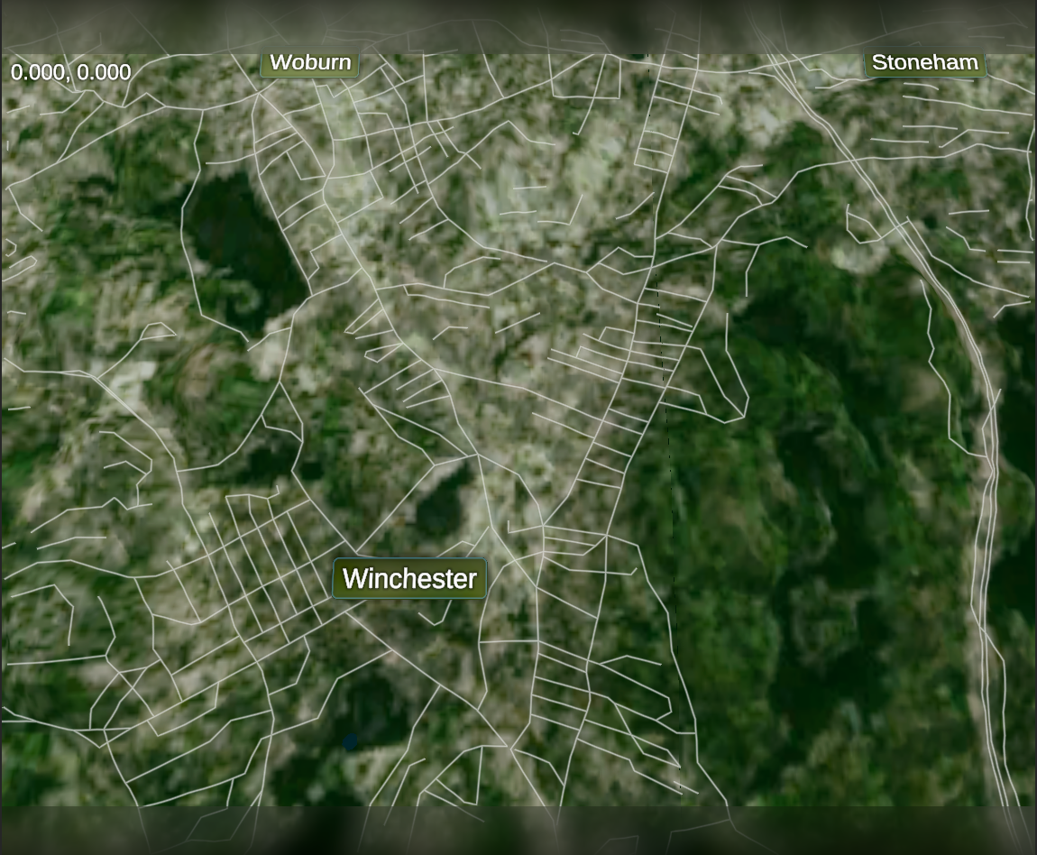
Getting to your question about "high-def enough": for vector/shapefile data, there is full resolution down to street level with no problem, because the data for this exists freely from the government. In first-generation WSV3, you had to manually download individual full heavy county local street shapefiles. In the next-generation WSV3, there is going to be an efficient, dynamic vector tile streaming system e.g. Google Maps. I actually intend to have CONUS-wide street-level vector shapefile (i.e. streets, counties, etc) vector tiles automatically download from server just like the raster imagery/elevation data, for a completely seamless experience. I intend to have actual angled text line labeling and road sign labeling. This satisfies the tactical requirement for GIS mapping data at higher resolutions than are probably ever necessary for mesoanalysis.
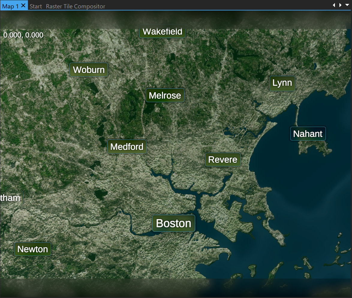
Now the "high def enough" raster data is the difficult part. It is not possible to have Google-level see-your-house satellite imagery because these datasets costs millions of dollars from companies like Maxar, etc. The great news is I have already acquired a private, commercial, paid-for dataset which is the best available in the industry for the money and which is widely used by companies, such as for creating in-flight avionics mapping. This goes down to what I currently have broken into 512x512 tiles at 0.125 (one-eighth) degree, both elevation and imagery, over CONUS. In my opinion, this is absolutely excellent and amply sufficient for the purpose of mesoanalysis.
Here are two screenshots showing what you can expect of this release-intended dataset at the tightest zoom level. Right now, I am not interested in solving the problem of getting data that is seamless and goes deeper than this, especially as I've already largely determined it's not possible without significant financial investment that can always become an eventual possibility given demand. We will probably release the final next-gen WSV3 with this base mapping, in terms of the highest resolution of the actual dataset.
I do have one innovative idea that could be pursued after release if demand exists for higher-res mapping. I could create a "community high-res raster map" crowdsourced imagery editing system where you can download certain non-seamless, limited-area, high-resolution orthoimagery datasets from public domain sources and manually touch them up/overlay rectangles specifying differently colored regions/specify color manipulations to manually try to stitch them together. This is the exact kind of work entire companies have spent millions of dollars doing on source datasets to produce beautiful, seamless mosaics down to street level like in Google Maps, which are not in the budget right now. Then you could "submit" your tile for review or there could be a credit system. Every so often the database would update. Google Maps does this for vector features, like if I want to suggest updates to a business's hours or correct an offset location.
Since processing orthoimagery data is such a huge topic, and since there are doubtlessly many nascent AI algorithms that could be used for this, getting deeper than 0.125 degree 512x512 raster imagery/elevation tiles is a great post-release project that should be measured in priority against the others. But, please tell me what you think about the current privately acquired commercial dataset and the level of resolution it has. With the vector mapping elements going to street level, I don't think the lack of color imagery at tighter zooms than this will impede tactical mesoanalysis, even though there are doubtlessly hypothetical rare examples where it could. These aren't to be discounted, but measured correctly in priority within an approximate 2-year development horizon.